As demand for safer roadways and more pathways in Kentucky continues to rise, Jessamine County hopes and plans to deliver. Developments in the county include reconstruction of the “Y” intersection, a trail along Lexington Road from the “Y” to Wilmore, a school connector trail in Nicholasville and a possible trail from Wilmore to High Bridge.
The state of Kentucky has plans to reconfigure the intersection of U.S. 68 and U.S. 29, referred to as the “Y.” In October 2019 a fatal accident occurred at the intersection as a car turned onto U.S. 29.
According to the Kentucky Transportation Cabinet (KTP) website, the current mapped proposal is to move the road behind the gas station to make a four-way stop with a traffic light. U.S. 29 would continue on the other side, curve and connect to Cardinal Drive.
“The purpose of this project is to provide an intersection that is safer to help reduce the number of accidents at the southern intersection of U.S. 68 and KY 29,” according to the website.
Included in the proposal is the extension of the paved path along highway 68 that leads toward Lexington. The city of Wilmore hopes to extend the path to Wilmore.
Member of the Wilmore City Council Andy Bathje said Wilmore is committed to making the trail happen, but construction cannot start until after the “Y” intersection is complete, which would be in the next few years. He said some landowners have already sold easements to the state for the intersection and trail. Easements allow cities and states to pay landowners to use a portion of their land.
Another path proposal is the school connector trail in Nicholasville, which would allow for safer commutes for students who walk to school. The trail would follow Wilmore road from U.S. 68 past West Jessamine High school, the three elementary schools, a middle school, the Early Learning Center, the Jessamine Career and Technology Center and East Jessamine High school.
“The idea of having a pathway that connects all your schools encourages kids to walk to school, walk back, as well as track teams using it, and then just recreation along that corridor,” Bathje said.
A preliminary engineering study on the Lexington Area Metropolitan Planning Organization website states, “The potential for regional connectivity to the west includes opportunities for connections to the existing U.S. 68 trail and eventual connection to the City of Wilmore. To the east, connection opportunities include the future U.S. 27 Eastern Bypass shared-use path and potential future Riney B Rail-to-Trail.”
Future construction on the Wilmore Road bridge over U.S. 27 include possible roundabouts and sidewalk additions. The KTP also has a proposal to construct an eastern bypass around downtown Nicholasville, completing the western bypass in a circle.
The opportunities for trail development in Kentucky are vast, especially when it comes to rail trails. Rail trails are abandoned rail lines that are converted to recreational paths.
The Abandoned Railroad Corridor Inventory Project, contracted by the KTP, found that the number of miles of railroads in Kentucky dropped from 4,000 at its peak to 2,760 in 2001. While other states had been converting many of their abandoned railroads to trails, Kentucky left many lines abandoned. Kentucky ranks 47th in the United States in terms of rail trail miles, according to the study.
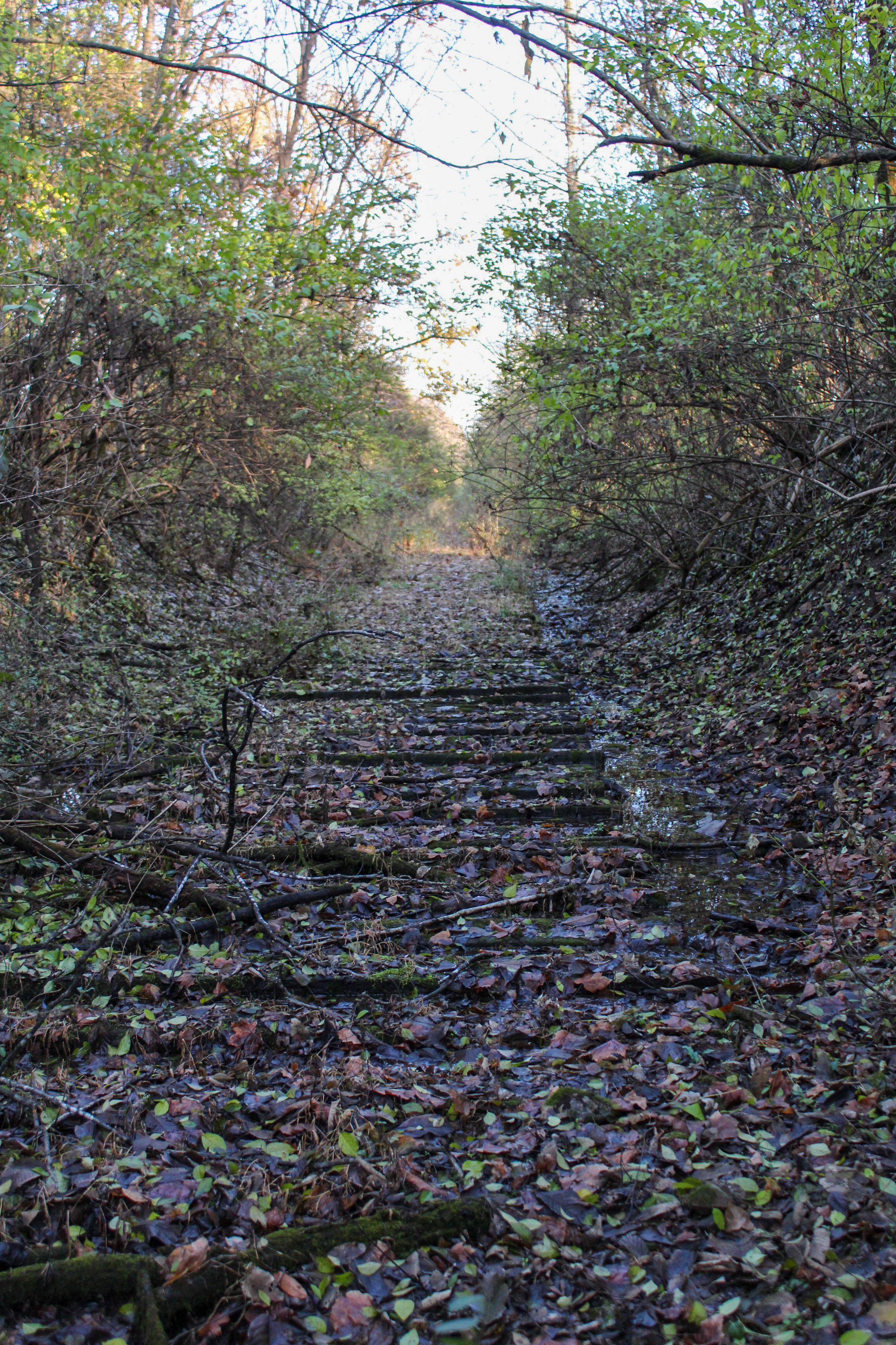
One abandoned rail bed sits between High Bridge and Wilmore. The line was abandoned sometime in the 1930s when High Bridge was rebuilt from a single to a double track.
According to a map on worldtimzone.com, the line starts along Kesterson Road near High Bridge and curves west to the Kentucky River. After following the river for a ways, it curves back toward High Bridge Road and eventually comes to the caboose in downtown Wilmore. Today, the trail sits in heavy overgrowth and many sections are on private property.
Bathje said Wilmore hopes to one day convert this historic rail line into a trail.
“We definitely dream about a Wilmore to High Bridge trail, and we’ve actually been calling that the ‘caboose to caboose trail’ because in downtown Wilmore you have the caboose and at High Bridge park is another caboose,” he said.
Bathje explained that roughly 15 years ago, he and the creator of worldtimzone.com, Tim Powell, made a proposal for the High Bridge trail and were able to raise funds of $2500 for it. But due to some landowner pushback against the idea, the proposal never moved forward.
Anytime a trail is developed, it influences neighborhoods in terms of property value and safety. According to a number of studies posted on Americantrails.org, while many Americans fear that trails near or on their property will reduce safety and property value, the opposite is generally the case. Studies on the website conducted in Colorado, California, North Carolina and other states found that trails increased or had no effect on property values, security and generally increased quality of life in the areas.
The abandoned railroad to High Bridge was once part of the Norfolk Southern Railway from Cincinnati to Tennessee. The stretch of track near High Bridge started the famous “Rathole Division,” nicknamed after the 27 tunnels across 160 miles of track between Wilmore and Emory Gap, Tennessee, according to the railroad magazine, Ties.
About halfway between High Bridge and Wilmore, one of the tunnels still exists, but according to Bathje, is partially filled with rockfall and junk.
While Bathje said the Wilmore City Council would love to have a trail to High Bridge, it doesn’t necessarily have to be along the old rail bed. He estimated that development for the trail would be around $1 million per mile, and the trail is five miles.
“I think the High Bridge trail will happen, the ‘when’ is the question,” said Bathje. “I think advocacy and even an expectation for pedestrian pathways is only going to increase.”
Bathje is currently head of the new Wilmore Trail Group, which meets to discuss pathways they would like to see around Wilmore. In addition to trails from Wilmore to the Y and to High Bridge, he said the group would like to see a trailhead shelter next to Solomon’s Porch. The shelter would act as a stopping point for runners and cyclers to park their bikes, take a break or explore downtown Wilmore.
News station WKYT posted Oct. 25 that a local abandoned track in Lawrenceburg will become a rail trail next year. The track went over the now-abandoned Young’s High Bridge from Versailles to Lawrenceburg. Currently, the east side of Young’s High Bridge is still partially in use by the Bluegrass Rail Museum. The west side is an overgrown path with wooden planks still on the ground.
The trail will be constructed on the west side and will cross the Cedarbrook viaduct, which is an 800-foot-tall steel bridge built in 1889 over Cedarbrook Road.
Bathje said he would love to see Asbury extend the Asbury trails to the north along the palisades. “I think it’d be really neat for Asbury and maybe in partnership with the city to create a loop trail out on the palisades land where you hike out past the equine barn and you just stay on top of the palisades.”
He continued, “You can hike just along the other side of the fenceline and you’re seeing the Kentucky River, and if a staircase were built down to the [Boone] tunnel … and then you were able to hike below the palisades along the river back to the Pump House Road, all that land is owned by Asbury University.”
Bathje said he enjoys the great number of nature trails Jessamine County has to offer; his favorite is the Jessamine Creek Gorge trail. The county has over 40 miles of coastline along the Kentucky River, and many public nature preserves exist on either side. A full list of trails and preserves can be found on jessaminetrails.com.